Sources
http://www.cmos.ca/weatherlore.html
http://earthobservatory.nasa.gov/Features/WxForecasting/wx2.php
http://www.noaa.gov/features/protecting_1208/weatherservice.html
http://www.crh.noaa.gov/lmk/?n=basic-fr
http://nsidc.org/arcticmet/factors/pressure.html
http://ww2010.atmos.uiuc.edu/(Gh)/guides/mtr/af/frnts/ofdef.rxml
http://www.ux1.eiu.edu/~cfjps/1400/pressure_wind.html
http://www.eetimes.com/design/programmable-logic/4216419/Radar-Basics---Part-2--Pulse-Doppler-Radar
http://www.weatherquestions.com/How_do_weather_satellites_work.htm
http://satellites.spacesim.org/english/function/weather/index.html
http://www.sciencedaily.com/releases/2008/05/080530174619.htm
http://www.usatoday.com/weather/wproverb.htm
picture from en.wikipedia.org
Wednesday, August 29, 2012
weather misconceptions
Groundhog's Day-
Aches-
Red Sky at sunset/rise bring good/bad weather respectively-
colored skies for tornadoes
halos around the sun and moon bring rain-
squeaking, and sticky furnature brings rain-
still wind brings good weather-
cows facing east/west-
months with R in them get bad weather-
onion skins tell the coming weather (thickness to coldness)-
This is a list of ten proverbs about the weather that I have gathered, some of these work, and some of them do not, to start with, I am going to eliminate all of those that have to do with long term predictions, the actions of animals, or fixed dates because they are always wrong. That means that months with Rs in them and thick onions skins in the fall do not bring bad weather, and cows are off the hook, as well as groundhogs. I found a website by the senior climatologist at Environment Canada from 1997, and it had a list of reliable weather proverbs, but no explaination as to why, but from that list we can say that squeaking furnature, halos around the sun and moon, and the red skys at sun rise and set, and are correct. For the joint aches it apears to be that drops in barometric pressure cause inlamation all around the body until the body has adjusted to the new pressures, and arthritic joints, being sensitized to the pressures of movement, are affected adversely by this inflamation. Many tales have to do with clumping salt of squeaking and stuck furnature predicting rain, this is because of moisture, wood swells in humid air, also the kind of air that causes rain when it moves. Halos around the sun and moon are caused by ice clouds very high in the sky, these are signs of more moist air, and cold air meeting, causing rain. Still wind is a sign of a high pressure zone, a large down draft, blowing weather away, and they do not often move very much. Finally, I come to the skies being pale yellow or green as an indicator of tornadoes, this is one from personal experience, having lived in Marshall Minnesota for six years, I do not remember a time that the weather alert radio did not issue a tornado warning when the sky was that color, or a time when the national defense sirens went when the sky was not that color, and I remember hiding from many tornadoes in that basement. I do not know if this is an accurate association but it certainly means rain and severe wind.
Meteorology and Weather Prediction
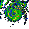 Two commonly used methods to gather information about the weather are radar and satellites. Weather radar uses microwave pulses to scan the air in a certain area, and discern characteristics about it, things such as wind speed, cloud cover, amount of precipitation, and other things. It does this by listening for the echoes of the microwave pulses, and creates and image according to how much reflected, and were it was reflected from that can then be interpreted by a person or a machine, it can also tell how fast things are moving by the phase shift recorded, essentially the microwaves come back a different color if they bounce of of moving object and the size of the phase shift allows the speed of the object to be calculated. The image to the top left is an animated pulse doppler radar image of a hurricane, the colors represent the speed of the clouds. Radar systems can be used to measure a surprising number of things, but most surprising to me is that they can be used to generate a fairly accurate estimations of the total volume of precipitation that has fallen.
 Weather satellites also provide a lot of information, they take high resolution images of the earth in the visual and infrared light ranges, these photos and videos are extremely helpful in weather forecasting, but most importantly, they help to identify other weather events that are hard to predict or detect with radar, things like wild fires, smog and pollution and large dust storms with very fine particles. These satellites are also useful for a variety of non weather related things, things like advising astronomers about light pollution, and keeping tabs on populations growth in cities. While they are not particularly useful for specific forecasts, they help to solidify the big picture created by our weather network, and see things that other methods of observation cannot. To the left is an image of a hurricane from a weather satellite.
Tuesday, August 28, 2012
Weather Fronts and Systems
 A cold front is when cold, almost always dry air moves towards the equator from the pole, these move much faster than warm fronts because they are denser than the preceding air mass, and so, instead of rising over top of it, cut underneath. Cold fronts often have a line of heavy rain right at their edge because they force the warm, often moist air up quickly, producing heavy rain. Cold fronts are narrow troughs of low pressure.

Fronts tend to move towards low pressure zones and away from high pressure zones, and in a clockwise direction, cold fronts approaching low pressure from the north and east, warm, mostly from the south and a little from the west. Along these fronts and a low pressure zones is were most "weather" happens, the bigger the temperature gradient and the moisture gradient between the air masses, the more sever the weather events are in general.

 This (left) is a typical low pressure system, with warm air being lifted by the cold front, and rising in advance of the warm front, and both circleing, if the warm air is moist that will create clouds like this (right). As the fronts circle the low pressure zone, the cold front will move much more quickly than the warm front, and eventualy they will collide, forming an occluded front, were all of the warm air mass is lifted over the cold air mass.
Monday, August 27, 2012
Weather Forcasts
This is the weather forecast for tomorrow form three different websites, each is slightly different. From
http://www.wunderground.com the high is 27, the low if 14, and it will be partly cloudy, form
http://www.accuweather.com there is a high of 30 and a low of 12, and it will be mostly sunny, and finally, from
http://www.weatheroffice.gc.ca there will be a high of 28 and a low of 13, and it will be completely sunny. Each of these is different because the weather is so enormously complicated that even with computer programs working 24/7 to predict the future, they still get it wrong most of the time. They are each different because each of them has slightly different measurements, and each of them has a slightly different model, and because the weather is so complex, even these slight differences can lead to sometimes radical differences in the overall projection of the weather for the future, and often lead to radical departures from what actually happens, especially for predictions more than 24 hours in advance. Weather prediction has been taking place for many years, probably since humans could communicate with eachother about things as complex as what the weather will be like tomorrow. This history of predictions has lead to a group of surprisingly accurate folk tales and short poems about the weather. Weather forcasting in the modern sense began soon after the invention of the telegraph, when it first became feasable to predict weather based on the current conditions upwind. Soon after that, the barometer was invented, and weather began to be predicted based on air pressure, and soon models and formulas were being created to predict the weather based on current weather conditions much more accurately, but after a certain point the calculations were so complex as to hardly be able to finish them before the weather actually happens. This all changed when computers came around, and soon enough, we had fairly accurate weather predictions for the next week or so.
Subscribe to:
Posts (Atom)